
Oct 2023 PM TCN
Q.1) At 2000 hrs., a vessel drops pilot at Simrishamn pilot station (55° 33.5’N 014° 24’E) and steers a
course of 071°(T) at 9 knots with the meteorological visibility being 5 miles. The vessel is to proceed to Karlsham pilot station (56° 08’N 014° 54’E). The Master decides to alter course when Simrishamn Lt. (Isp. WRG 6s) obscures (last seen). After altering course, she is to pass Hano Lt. {Gr. Fl.(3) 15s} in position 56° 01’N 014° 51’E 3 miles on the port side. If the current is known to be setting 120°(T) at 2 knots, find the time and position when:
i) Vessel alters course towards Hano lt:
ii) Hano Lt. is sighted.
Answer:
Simrishamn Lt:
Geographical Range – 2.095√10+2.095√16 = 15M
Nominal Range – 13M
Luminous range – 8.2M
Hano Lt:
Geographical Range – 2.095√10+2.095√70 = 24.15M
Nominal Range – 24M
Luminous range – 14.2M
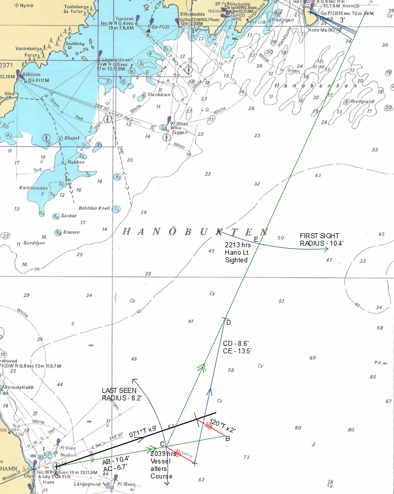
i) Time vessel alters Course – 2039 hrs / Position: 55°35.2’N; 014°36.0’E
ii) Time Hano Lt Sighted – 2213 hrs / Position: 55°47.3’N; 014°46.0’E
Q.2) A vessel steering course 258° (T) observes UTKLIPPAN Lt. house (55° 57’N 15° 45’E) to bear 285°(T) at 2100 hrs, 297°(T) at 2120 hrs, and 034°(T) at 2150 hrs. The current was estimated to set 304°(T). Find the vessel’s position at 2150 hrs, the course made good and the rate of current. Ship’s Speed 12 Kts
Answer:
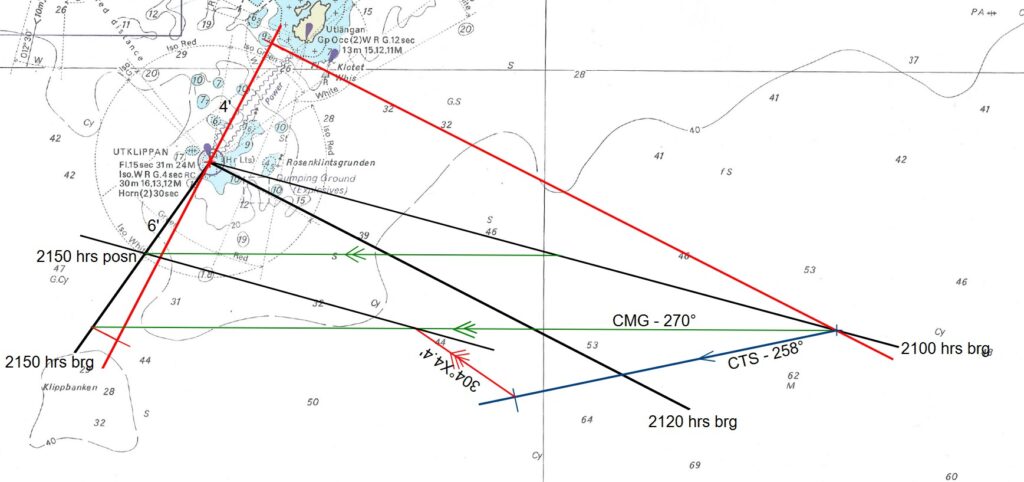
2150 Hrs Posn – 55°54.6’N; 015°38.6’E
CMG – 270°T
Rate – 4.4 Kts
Q.3) A vessel at anchor South of YASTAD observed the following compass bearings:
Sandhammaren (55° 24’N. 14° 10’E) 067°C
Yastad (South) (55° 25’N. 13° 49’E) 010°C
Abbekas (55° 23’N. 13° 16’E) 320°C
Find the vessel’s position and compass error. From this position, plan a passage to reach the VTS off OLAND’S SODRA GRUND (56° 04’N, 16° 41’E) via KARLSHARMM (56° 10’N, 14° 52’E) where she has to go for discharging a small parcel of cargo.
See July 2021 Q3 for Answer