Apr 2024 PM TCN
Q.1) At 0200 hrs straight Pt. Lt. (50° 36.6’N & 003° 21.7’W) bore 300°(T) when the vessel crossed 30 m contour. Find the ships position, from this position find the course to steer to pass bill of Portland Lt. (50° 31’N, 002° 27’W) 9’ off port. Engine speed 12 kts, vessel experiencing a NE’ly wind causing a leeway of 5O current setting 180O(T) x 2 Kts. Also find the time & position, when the vessel will pass bill of Portland light 9’ off. Engine speed 9 kts.
Answer:
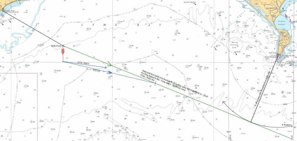
CTS – 098°T
Time the vessel will pass bill of Portland light 9’ off at Engine speed of 9 kts – 0450 Hrs
Q.2) Vessel in position 50°15’N 003°W at 2000 hrs, find the course to steer to first sight Bill of Portland
Lt right ahead counteracting a tidal stream running at D. At what time & position the above Lt will be
first sighted. HW at Devenport at 2330 hrs at Spring tide. HE 9m, Met Visibility 2M, Engine speed 12
kts.
Answer:
Raising Distance = 2.095√43+2.095√9 = 20’ => Geographical Range
Nominal Range – 29M
Present Luminous range – 7.8’
From Chart: 03 hrs 30 mins before HW – Set & Rate = 261.5°T x 2.05’
Drift = (Raising Distance x Rate of current) / Engine Speed
= (7.8 x 2.05) / 12
Drift = 1.3 Kts
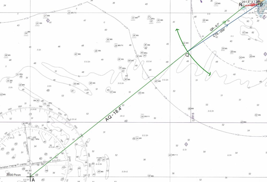
To find SMG:
SMG = (QR x Engine Speed) / Raising distance
QR = 6.7’
SMG = (6.7 x 12) / 7.8 = 10.3 Kts
CTS = 056°T
Total Distance AQ 2000 hrs to First sight Posn = 18.4’
Time taken = 18.4/10.3 = 1 hr 47 min
Bill of Portland light will be first sighted at 2147 hrs
Position: 50°26.8’N; 002°37.6’W
Q.3) Plan a passage from deep sea pilot station (50° 25.2’ N, 003° 27’W) to port land Harbour (50° 35’ N, 002° 26’ W). Your vessel is fitted with Radar, GPS, Gyro, Echosounder. Courses, distances, Way
points, no go areas etc to be clearly marked on chart and write on answer sheet. Draft of your vessel
12 mtrs maximum Engine speed 14 kts.
Plan the Passage as per question